
Tags
1881 map of Ninewells wood, Catbrook wood, Cicelyford, History of Ninewells wood, Monmouthshire, Ninewells Wood, Old maps of Ninewells wood, Wye valley
In my quest to find out as much as I can about Catbrook wood and Ninewells wood in general, I have been looking at some old maps of the area. The ordanance survey maps are on various scales but the most detailed seem to be 1:2,500 and the earliest I have found is from 1881, then there is one from 1902, followed by 1922 and finally 1972.
By comparing them one can see that very little has changed over the years, lets start with the 1881 map and the first thing that I notice is that the pattern of the wood with the footpaths and boundaries is virtually the same as it is today. The wood does have two sections in what is now my neighbours farm and of course the two bungalows are not there, in fact they do not appear until the last map in 1972. Also the name of the area Cicelyford was different back then, it was Ceciliford; Who was Cecil? Was there a river of stream called Cecil?
If you want a closer look at any of the maps then click on it and it will come up a bit bigger.
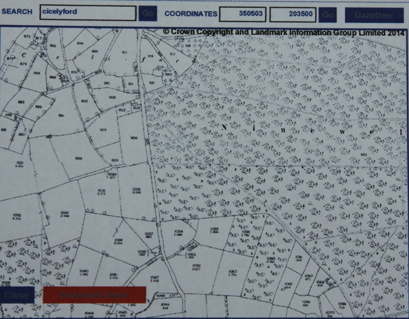
1881 map of Ninewells wood
By carefully looking at the symbols on the wooded area one can see that most of the woodland is deciduous at this stage,but there are some symbols for pine trees in the lower part of what is now called Catbrook wood and also in the two plots which now are fields and part of my neighbours farm.
In the next map from 1902 one can see that the two sections of wood (plots 1047 and 1048 have now been removed, well almost, there still remains a tiny portion in plot 1047, probably amounting to just a few trees.
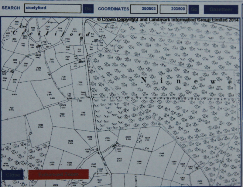
1902 map of Ninewells wood
The other thing which appears to be different is that the symbols seem to indicate a line of large trees along the main path through the centre of Ninewells wood which were not marked in the 1881 map.
Moving on to the 1922 map and we can see that the little bit of woodland that remained in plot 1047 has now gone, but several plots have been planted up on the other side of the road, and it looks like they are conifers.
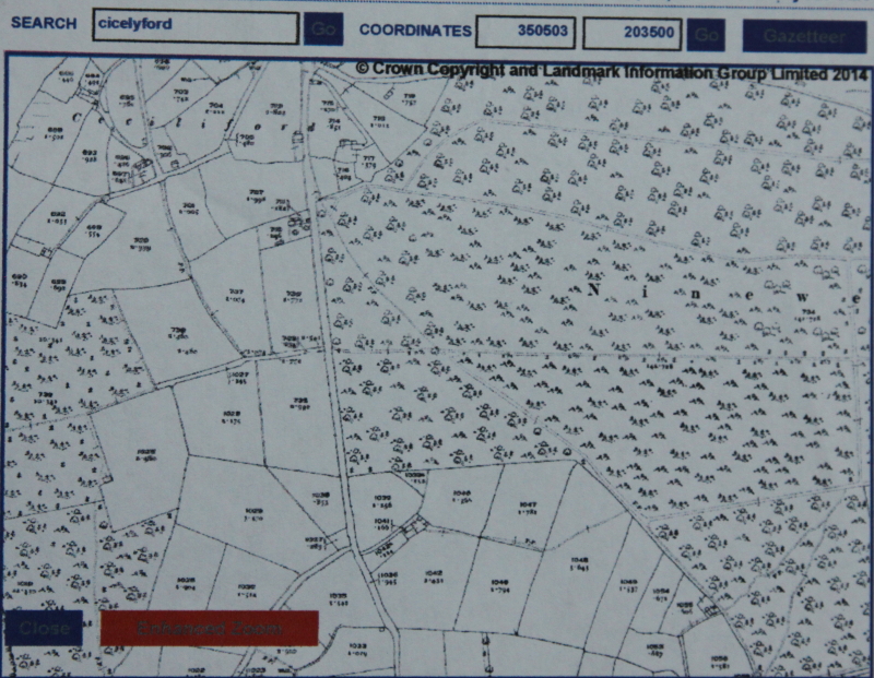
1922 map of Ninewells wood
Also it would appear that the symbols denoting the type of vegetation have changed, most of the lower half of Ninewells wood has a symbol which does not depict deciduous trees. I am not sure what it does show, possibly a mix of rough ground or small pines. The region of Catbrook wood seems to be now all the same and seems to show deciduous trees. This is somewhat confusing as in 1902 it was half pine and half deciduous?
Finally lets move onto the 1972 map and this now shows a road up to the two bungalows, one called ‘The Larches’ and the other called ‘High View’. Also one can see that a fairly substantial track has been made along the route of the path which is towards the top of Ninewells wood. This is now a Forestry commission path and presumably was constructed by them in the first place.
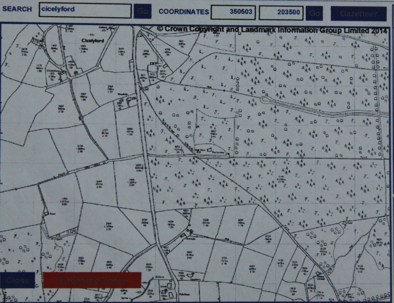
1972 map of Ninewells wood
The woodland that appeared in the 1922 map has now gone ( 50 years being sufficient for a crop of pine trees to grow to a harvestable size) Also the symbols depicting the type of trees growing in Ninewells wood suggests mainly pine but still some deciduous in parts.
If anyone has any old maps of this region, or photos or any memories of what went on in days gone by, then I would love to know and could add them to this site. Do let me know.
I do not think I have done anything wrong by showing these maps, they do say Crown Copyright which sounds quite intimidating but I am not reproducing them for commercial gain. They are freely available on the internet so anyone can look at them and all I am doing is presenting them all together so you can more easily compare them. If I have transgressed then I will remove them if that is necessary.

Pingback: Ninewells wood, an ancient woodland ? | Ninewells Wood/Catbrook Wood
Hello there
I wanted to pass on my thanks to you for your wonderfully informative blog. I have recently started to walk Ninewells and it is by far one of my favourite woods! Can you tell me if there have ever been any ‘wells’ or does the name relate to the springs only? There is such an amazing landscape of stone and rock scattered and I am curious to know if this is natural or relics of old wells … I am sure I have found a circular rock that looks like a mill stone! I would love to know more and to hear more about your own woodland too! Many thanks Tina
Thanks, I think it is all based on springs. There is a well in our portion of the wood but as has been pointed out several times by locals it is not one of the nine wells/springs. It was dug just prior to mains water being available and so was never really used. The watch tower is an interesting feature, you have no doubt seen that.
Thank you for replying! You are so lucky to have a well in your woodland too. I appreciate your wonderful local knowledge, it makes walking these woodlands an interesting experience. I have seen the watch tower, which I initially thought was a well … I plan to find the fox engraving on my next visit, which I have just learnt about from your blog. I am so interested in the history of this wood too so again thank you for your articles.
I am glad you are enjoying it, maybe we will bump into each other sometime. My well is not that exciting it is just a hole in the ground with a very rough wall round it…. wall? pile of stones.